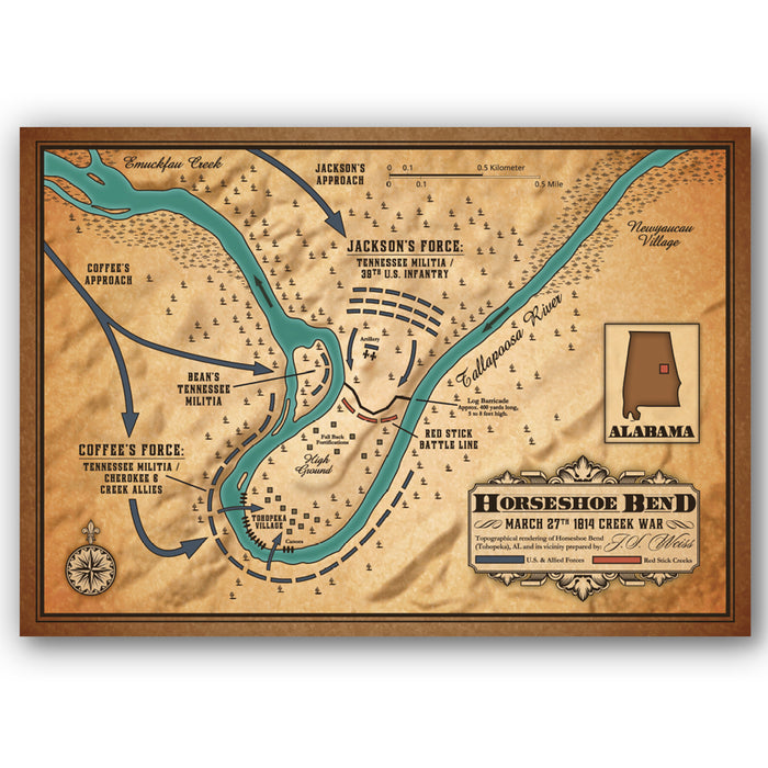
Battle of Horseshoe Bend (Creek War) Map
“[They] fought to the last with that kind of bravery desperation inspires…”
In March 1814, Major General Andrew Jackson’s army of 3,300 men left Fort Williams along the Coosa River in Alabama. In three days, they cut a 52-mile trail through thick forests, setting up camp some six miles north of a horseshoe-shaped bend, and Red Stick Creek warrior stronghold, on the Tallapoosa River. On March 27, Jackson sent General John Coffee, along with 700 mounted infantry and 600 Cherokee and Creek allies three miles down-stream to cross the river and surround the bend. Next, Jackson stationed the rest of his army into the peninsula and, by the morning, began an ineffectual two-hour artillery bombardment of the Red Sticks’ log barricade. By afternoon, General Coffee’s Cherokee allies had encircled the Red Sticks and attacked from the rear, as Jackson ordered a frontal bayonet charge that decimated the defensive barricade. By night fall, 800 of Chief Menawa’s 1,000 Red Stick warriors sacrificed their lives.
This full-colored render of Horseshoe Bend (Tohopeka), Alabama by Justin S. Weiss details troop movements and fortifications present during the Battle of Horseshoe Bend. This pivotal battle effectively ended the Creek War and resulted in a land cession of 23,000,000 acres to the United States. It also made future president Andrew Jackson a national hero.
Product Details
- 20”x 14” print by Justin S. Weiss
- Depicts the Battle of Horseshoe Bend—a decisive engagement during the Creek War and broader conflict of the War of 1812
- Rendered from R.H. McEwen’s original 1814 sketch “Map of the Battle of Horseshoe Bend of Tallapoosa River, 27th March 1814”
- Printed in USA, published by Eastern National